|
 |
Hi(gh)!
After rendering some views of Cologne (which are not really spectacular,
as terrain relief is virtually non-existing in the Rhenish plain) I went
on with something more impressive: Afghanistan! More precisely, the
Kabul basin with the adjacent Shomali plain to the north, surrounded by
the Paghman Range (west), the Central Hindu Kush with the
famous-infamous Salang Pass (north) and Koh-e Safi (east).
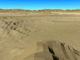
I just completed my very first two renderings of the region, the first
picture attached here is a view from a southern mountainside straight
north across the (not yet existing) city of Kabul towards the Hindu Kush
in the distance (with the camera placed 100 metres above the ground),
the second picture shows the Paghman range from the same view point.
Many more views are planned!
Probably some of you might remember that I came up with views of the
Kabul area already in 2007... back then, I used a flat heightfield made
from a topographic map rather than mesh2s following Earth's curvature.
The resolution of this heightfield was about 12 metres per pixel,
compared to 30 metres with the current ASTER elevation data
(effectively, it's only about 41.5 metres as I'm currently not able to
make use of the full data resolution due to RAM limitations I probably
might not overcome before 2014), but it is an extremely cumbersome work
to manually generate that heightfield, and there is still the problem of
converting the original topographic map's geodetic coordinates to
geographic ones...
In the future, I want to continue with modeling both Cologne and Kabul
(thus I will be seen more often handling around with camera, folding
rule and slide caliper in the public)... it will by an extremely
challenging task, as I of course plan to populate my terrain meshes with
bodies of water, vegetation and buildings... and modeling an entire city
would be best accomplished by a team of POVers! Cologne Cathedral alone
would take a single POVer many years to complete... any Colognians
around to join me? Christoph Lipka? Tom Aust? Oh, I dream of a whole
movement of hundreds of thousands POVers devoted to POVEarth...
What the world needs is a MASSIVE campaign to promote POV-Ray! Not only
on the Internet, but also out on the streets, with information stands,
billboard advertising (in 2003, I saw in a London subway station an
advertising billboard promoting a commercial raytracing system...),
people wearing the POV logo on T-shirts or even tattooed, car license
plates containing POV in some ways...
See you in Khyberspace!
Yadgar
Post a reply to this message
Attachments:
Download '2013-07-10 view over kabul and shomali plain from south, take 1.jpg' (92 KB)
Preview of image '2013-07-10 view over kabul and shomali plain from south, take 1.jpg'
|
|


